Top 5 Agricultural Inspection Drones in Canada for 2026
Published on Sunday, January 4, 2026
Agricultural inspection drones are revolutionizing the way farmers in Canada monitor their crops, assess plant health, and maximize yields. These cutting-edge technological tools allow for high-resolution aerial imaging and precise mapping of agricultural fields, providing critical insights to farmers. In a landscape where efficiency and data-driven decision-making are paramount, the appeal of these drones lies in their ability to save time, improve crop management, and ultimately increase profitability. With the vast diversity of crops grown across the Canadian provinces, the adoption of agricultural inspection drones is becoming increasingly prominent, fostering healthier ecosystems and sustainable farming practices.
Top Picks Summary
DJI Agras T30
The DJI Agras T30 is a leading agriculture drone recognized for its high-efficiency spraying capability and advanced AI technology. It features a powerful payload capacity, allowing it to cover vast agricultural fields quickly and effectively. With its real-time data analysis and intelligent flight planning functionalities, farmers can optimize their crop health management like never before. Additionally, its dual-battery system ensures extended flight times, making it a top choice for commercial agricultural applications.

senseFly eBee Ag
The senseFly eBee Ag is a market leader in aerial mapping and surveying solutions, particularly for agriculture. Known for its ease of use and versatility, it offers a variety of payload options, including multispectral cameras for precise crop analysis. This fixed-wing drone provides long flight times and extensive coverage, making it ideal for large agricultural areas. Its robust data collection capabilities allow farmers to make informed decisions about their farming practices, ultimately leading to increased yields.

$18,000 – $24,000
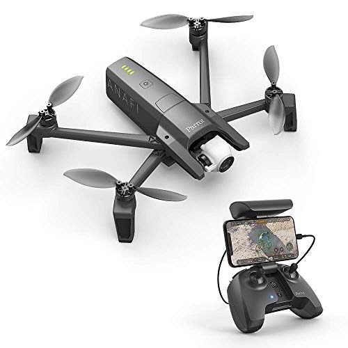
Parrot Anafi
The Parrot ANAFI Ai stands out in the drone market with its cutting-edge AI-powered features tailored for professional use. It boasts a unique 4K HDR camera with a 32x zoom capability, making it perfect for detailed aerial photography and mapping. Its compact design and robust connectivity options, including 4G, enable seamless operation and data transmission in various environments. Parrot’s commitment to user-friendly software also simplifies data analysis, setting the ANAFI Ai apart from competitors.
Autel Robotics EVO II Dual 640T RTK
The Autel Robotics EVO II Dual 640T RTK combines thermal and visual imaging, making it a formidable tool for a variety of professional applications, including agriculture, search and rescue, and surveillance. Its 640x512 thermal sensor provides unparalleled detail, allowing users to easily identify temperature variations in crops or search targets. The RTK module ensures centimeter-level accuracy, which is essential for precision tasks. Additionally, its impressive flight time and robust construction make it a reliable choice for demanding environments.

$6,000 – $12,000
Quantix Mapper
Quantix Mapper offers a revolutionary solution for agricultural mapping with its advanced hybrid drone technology. Combining vertical takeoff with fixed-wing capabilities, it captures high-resolution imagery over large areas efficiently. This drone is particularly noted for its smart data processing and seamless integration with farming management software, helping farmers improve operational decision-making. Its ease of use and quick deployment make it an essential tool for modern agriculture.

$17,000 – $20,000
High-resolution cameras, multispectral sensors, and real-time data analysis capabilities allow agricultural inspection drones to optimize farming practices effectively.
Learn About the Benefits of Agricultural Inspection Drones
Understanding the advantages of agricultural inspection drones can significantly enhance farming practices. These drones provide real-time data that empowers farmers to make informed decisions.
High-resolution imaging helps detect crop health issues early, allowing for timely interventions.
Mapping capabilities enable precise field analysis, optimizing planting strategies and resource allocation.
Data-driven insights improve yield predictions and assist in effective management practices.
Drones reduce operational costs by streamlining monitoring tasks and minimizing labor.
Sustainable practices are promoted through targeted treatment applications, reducing chemical usage.
Increased efficiency leads to better time management, allowing farmers to focus on other critical areas of their operations.
Frequently Asked Questions
Which drone should I buy for crop spraying in Canada?
Choose DJI Agras T30 if you need efficient crop spraying: it has a high payload capacity for spraying and an average rating of 4.9.
What imaging capability does Parrot ANAFI Ai offer?
Parrot ANAFI Ai includes a 4K HDR camera with a 32x zoom capability, plus real-time data transmission, with an average rating of 4.4.
How does DJI Agras T30 price compare to senseFly eBee Ag?
DJI Agras T30 lists at $139.01 CADwhile senseFly eBee Ag has no price shown here; eBee Ag’s average rating is 4.4.
Does senseFly eBee Ag support accurate mapping for farms?
Yes—senseFly eBee Ag lists high-precision GPS for accurate mapping, and it’s versatile for various surveying applications, with an average rating of 4.4.
Conclusion
As we look to the future of farming in Canada, agricultural inspection drones are emerging as indispensable tools for successful crop management. We hope you found this information helpful, and if you're looking for more specific details or other inquiries, feel free to utilize the search bar.