Top 5 Cadastral Mapping Drones in Canada, 2026
Published on Thursday, January 1, 2026
Cadastral mapping drones are specialized UAVs designed for precise land survey and property boundary detection. They play a critical role in establishing legal land ownership and facilitate urban planning by providing accurate geospatial data. With the increasing demand for efficient land management and urban development in Canada, these drones are becoming a preferred choice for both residential and commercial applications. Their ability to gather high-resolution imagery and data rapidly makes them invaluable tools for surveyors, real estate professionals, and city planners.
Top Picks Summary
senseFly eBee X
The senseFly eBee X is a leading fixed-wing drone designed for professional surveying and mapping. With its impressive flight time of up to 90 minutes and a range of sensor options, it excels in versatility and efficiency, allowing users to cover extensive areas in a single flight. The eBee X's lightweight design and robust construction make it ideal for various environments, ensuring its reliability and performance in diverse applications. Its user-friendly interface and advanced capabilities set it apart from competitors in the mapping sector.

15,000-20,000$
DJI Phantom 4 RTK
The DJI Phantom 4 RTK combines the reliability and usability of the Phantom series with powerful RTK capabilities, offering centimeter-level accuracy for surveying and mapping projects. It is equipped with advanced obstacle sensing technology, enhancing safety during flight operations. The intuitive control system and comprehensive software solutions make it accessible for both novice and experienced users. This market-leading drone stands out for its superior camera quality and robust performance in professional-grade applications.

6,000-8,000$
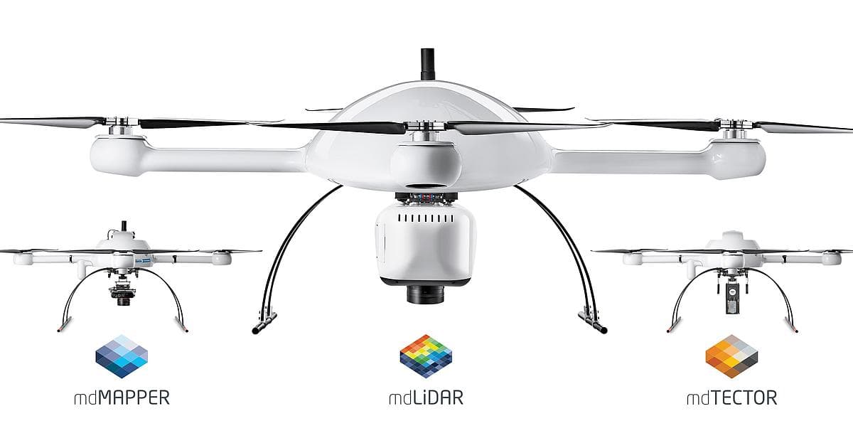
Microdrones mdMapper3000DμoG 3D
The Microdrones mdMapper3000DμoG 3D is a groundbreaking drone-based mapping solution tailored for geospatial professionals. Its integration of high-precision photogrammetry with robust automation features allows for efficient data capture and processing. The mdMapper3000DμoG stands out with its ability to deliver high-resolution results in an incredibly short time frame, making it a top choice for large-scale mapping projects. Its reliability and precision set a new standard in the aerial mapping industry.
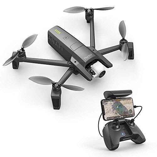
Parrot Anafi
The Parrot Anafi USA is a versatile drone tailored for professional and enterprise use, featuring advanced imaging capabilities including a 32x zoom and thermal camera. Its lightweight and foldable design ensures portability without compromising on performance, making it ideal for quick deployments in the field. The Anafi USA integrates AI to assist in creating high-quality geospatial data, ensuring users can easily gather crucial information during critical operations. Its multifunctionality distinguishes it from others in the competitive landscape.
Delair UX11
The Delair UX11 is a high-performance fixed-wing drone designed specifically for industrial and surveying applications. It boasts a remarkable flight endurance with the ability to cover large areas efficiently and is optimized for precision mapping. The UX11 is equipped with advanced sensors, including RGB and multispectral options, allowing for tailored data collection based on project requirements. Its focus on optimizing aerial data quality and processing makes it a favorite among professionals seeking reliable drone solutions.

Integration with GIS software and high-resolution imagery for accurate boundary mapping.
Understanding the Benefits of Cadastral Mapping Drones
Cadastral mapping drones offer a range of significant benefits for land management and urban planning. Let’s delve into how they can transform these industries:
Faster Data Collection: Drones can cover large areas in just minutes, which significantly reduces the time needed for on-site surveys.
Improved Accuracy: Equipped with advanced GPS technology, cadastral drones deliver high-resolution imagery that ensures precise boundary detection.
Cost Effective: By minimizing manpower and time invested in traditional surveying methods, these drones reduce overall project costs.
Enhanced Safety: Cadastral drones can access difficult terrain easily, minimizing risks to surveyors and reducing potential hazards related to land surveys.
Real-time Data: The ability to capture and process data on-site allows for immediate analysis, leading to quicker decision-making in urban planning.
Sustainable Practices: By utilizing drones, survey operations significantly decrease the environmental impact compared to conventional surveying methods.
Frequently Asked Questions
Which drone should surveyors pick for large areas?
For large-area mapping, the senseFly eBee X is designed for professional surveying with long flight time up to 90 minutes, letting you cover extensive areas in a single flight, and it has an average rating of 4.6.
Does the DJI Phantom 4 RTK support RTK accuracy?
Yes—the DJI Phantom 4 RTK includes high-precision RTK capabilities and has obstacle avoidance technology plus an integrated camera; it’s rated 4.7 on average, and it’s made for surveying and mapping.
How does the senseFly eBee X compare in value?
The provided info for the senseFly eBee X lists a flight time up to 90 minutes and multiple payload options, with an average rating of 4.6, but it does not include any price for value comparison.
What warranty coverage is offered for Microdrones mdMapper3000DμoG 3D?
The provided product data for the Microdrones mdMapper3000DμoG 3D does not state any warranty duration; it only notes advanced mapping features with 3D capabilities and an average rating of 4.6.
Conclusion
In summary, cadastral mapping drones represent a transformative advancement in surveying and urban planning in Canada for 2026. Their capabilities enhance the efficiency of land management while ensuring precision in property boundary detection. We hope you found the information you were looking for. If you have specific queries or need more detailed insights, don't hesitate to use our search bar.