Topographic Surveying Drones in Canada: Top 5 Picks for 2026
Published on Tuesday, July 21, 2026
Topographic surveying drones are essential for capturing elevation data and terrain features. They provide essential insights for planning and development applications across Canada, from urban infrastructure projects to remote resource sites and forested watersheds. In 2026, surveyors and engineering teams choose these platforms because they deliver fast, repeatable, survey-grade digital elevation models, orthomosaics, and point clouds with reduced field time and improved safety. Canadian buyers tend to prioritize accuracy (RTK or PPK), LiDAR or high-resolution photogrammetry capability, battery and sensor performance in cold climates, long endurance for wide-area mapping, and local support and parts availability. Other deciding factors in the Canadian market include regulatory compliance with Transport Canada rules, payload flexibility, integration with GIS and CAD workflows such as Esri and QGIS, and proven performance in diverse terrain types from coastal zones to mountainous and boreal regions.
Top Picks Summary
DJI Matrice 350 RTK
The Matrice 350 RTK is positioned as the market-leading enterprise multirotor for topographic surveying thanks to its modular payload support, integrated RTK and strong reliability across harsh-site operations. It outperforms consumer-class systems on endurance and sensor flexibility (so teams can use LiDAR, high‑res photogrammetry or thermal without buying multiple platforms) and delivers a lower total cost of ownership on multi-mission programs compared with single-use drones. Against fixed‑wing solutions in this list it trades raw area efficiency for superior maneuverability, repeatability and rapid deployment in complex survey sites.

DJI Phantom 4 RTK
The Phantom 4 RTK is the go-to compact mapping drone for survey teams who need survey-grade coordinates on a tight budget, combining an integrated RTK module with DJI’s mature data workflow. It provides a cost-effective entry to professional topographic surveys and faster training and support than many alternatives, though it lacks the multisensor payload versatility and enterprise redundancy of the Matrice 350 RTK. Compared with fixed‑wing options here it is better for confined or vertical sites but less efficient per hectare for large-area projects.

$8,000-11,000 CAD
senseFly eBee X
The eBee X is the fixed‑wing leader for large-area topographic mapping, offering long endurance, multiple professional camera options and PPK/RTK workflows that drive down cost per hectare on big surveys. Its flight efficiency and payload choices make it technically and financially superior for wide-area projects compared with multirotors on the list, though it is less suitable for small, constrained sites where VTOL or multirotor agility matters. For large-scale cadastral, forestry or mining surveys it often represents the best balance of speed, coverage and data quality.

$20,000-45,000 CAD
DJI Inspire 2 avec Zenmuse Z30
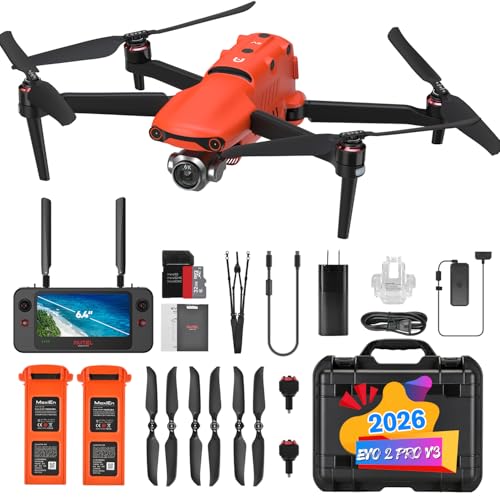
The EVO II Pro RTK delivers a strong price-to-performance proposition for survey teams needing high-resolution imagery with integrated RTK accuracy in a highly portable airframe. It competes with the Phantom 4 RTK on affordability while offering improved sensor flexibility and flight endurance for many field workflows, but it does not match the enterprise payload ecosystem or redundancy of the Matrice series. As a budget-conscious professional option it reduces upfront capital outlay while delivering much of the photogrammetric quality required for topographic deliverables.
WingtraOne GEN II
The WingtraOne GEN II is a VTOL fixed‑wing designed specifically for precision topographic surveys, combining fixed‑wing endurance and efficiency with vertical takeoff for confined sites, and offering high‑quality camera and PPK options for survey-grade results. It often beats pure multirotors on cost per hectare and delivers more consistent GSD across large areas than small multirotors, while its VTOL capability gives it an advantage over conventional fixed‑wing rivals for site access and operational simplicity. For mapping firms focused on medium-to-large site accuracy with limited runway space, it represents a compelling technical and economic choice.

$35,000-70,000 CAD
Research and Evidence Backing Drone Topographic Surveys
A growing body of research and technical reports supports the use of unmanned aerial systems for topographic mapping. Studies from national agencies and academic groups show that modern drones equipped with RTK or PPK positioning and calibrated photogrammetric workflows can achieve survey-grade results suitable for many engineering and planning tasks. UAV-mounted LiDAR has been shown to recover ground points under vegetation more effectively than photogrammetry alone in forested environments, and combined LiDAR and imagery workflows improve classification and feature extraction. Peer-reviewed work and government field trials also document large time and cost savings compared with traditional ground-based surveys when surveying medium to large areas.
Accuracy: RTK and PPK-enabled photogrammetry workflows commonly produce horizontal and vertical accuracies in the low centimeter range for well-controlled surveys.
Vegetation and canopy: UAV LiDAR systems can penetrate canopy and provide denser ground returns in forested areas than photogrammetry alone, improving DEM generation.
Efficiency: Case studies show significant reductions in field time and overall project cost for site-scale topographic mapping versus conventional methods.
Best practices: Ground control points, sensor calibration, proper flight planning, and post-processing with established photogrammetry or LiDAR software are key to achieving survey-grade deliverables.
Limitations: Weather, wind, cold temperatures, battery performance, and regulatory restrictions such as line of sight and airspace approvals remain practical constraints that operators must manage.
Frequently Asked Questions
Which drone should I buy for topographic surveying teams?
For enterprise topographic surveying, the DJI Matrice 350 RTK is a strong choice with integrated RTK and redundant flight systems plus modular payload support for Zenmuse P1/L1 and third-party sensors; it’s rated 4.7.
Does DJI Phantom 4 RTK support centimetre-accurate geotags?
Yes—DJI Phantom 4 RTK includes an onboard RTK module that provides centimetre-accurate geotags for high-precision surveys, paired with an integrated 1-inch 20MP camera optimized for high-overlap orthomosaic; rating 4.7.
Is the DJI Phantom 4 RTK worth the price 12677.24 CAD?
At 12,677.24 CAD, DJI Phantom 4 RTK gives a compact, easy-to-deploy platform with survey-grade RTK geotags and an integrated 1-inch 20MP camera for high-overlap orthomosaic; rating is 4.7.
Which drone works best for large-area fixed-wing mapping?
Choose the senseFly eBee X for large-area topographic mapping: it uses a long-endurance fixed-wing airframe for big surveys in a single sortie and supports multiple professional payload options like S.O.D.A., Duet, and multispectral sensors; rating 4.6.
Conclusion
In Canada the topographic surveying drone choices for 2026 balance accuracy, endurance, and support. The DJI Matrice 350 RTK stands out as the best overall choice for most professional survey teams thanks to its versatile payload options and wide dealer support. The DJI Phantom 4 RTK remains a strong, cost-effective option for smaller mapping projects. The senseFly eBee X excels for long fixed-wing coverage and efficient photogrammetry. The Autel EVO II Pro RTK provides a powerful alternative with excellent sensor options, and the WingtraOne GEN II is ideal where vertical takeoff fixed-wing performance and high-accuracy mapping are needed. I hope you found what you were looking for; use the site search to refine or expand your search by payload type, accuracy, endurance, or budget.