Best Map Plotting Protractors and Map Scales in Canada - Top 6 for 2026
Published on Thursday, February 26, 2026
In the world of navigation and cartography, precision is key. Whether you are a seasoned hiker, a land surveyor, a search and rescue volunteer, or a mapping enthusiast, the right map plotting protractor and scale can make a significant difference in accuracy and ease of use. In Canada, where varied terrain and long distances demand reliable tools, consumers favor instruments that combine accuracy, durability, and portability. Modern map plotting tools deliver clear, easy-to-read markings, multiple distance scales (including metric and imperial), UTM and MGRS readouts, and robust materials that resist wear in wet or cold conditions. These devices are essential companions for route planning, backcountry travel, field surveying, and classroom mapping exercises. For 2026 the market highlights tools that balance traditional mechanical precision with user-friendly layouts, lightweight construction for backpacking, and durable plastics or coated metals that perform in Canadian conditions.
Top Picks Summary
MapTools Super GTA Tool
The MapTools Super GTA Tool is a specialized map plotting protractor engineered for converting Grid, True and Azimuth bearings directly on map scales, making it indispensable for precise grid-to-true angle work and military-style plotting. It secures its position as best-in-class among protractor tools for this use case because it supplies conversion and plotting functionality that standalone compasses lack, offering a clear technical advantage for map-scale correction and professional plotting workflows; its price sits between classroom protractors and electronic plotters, representing a strong value for specialists. When paired with accurate compasses, the Super GTA Tool removes much of the manual calculation, streamlining scale-aware plotting tasks.

C-Thru W-45 Protractor
The C-Thru W-45 Protractor is a transparent acrylic plotting protractor made for map-reading, scale measurement and quick angle transfers; its clarity and printed scale sets make it an affordable, easy-to-use choice for classrooms and fieldwork. It ranks here as the economical, no-frills protractor option—significantly less expensive than precision tools like the MapTools Super GTA—while still providing the essential functionality for plotting on standard map scales, though it lacks the conversion and advanced plotting features of specialized tools. For users focused on low-cost, reliable map-scale measurement and basic protractor tasks, the W-45 delivers strong technical value per dollar.

Silva Expedition Type 4 Military Protractor
The Silva Expedition Type 4 Military Protractor is prized for its military-style clarity and durable construction, making it a dependable choice for land navigation and map plotting. Its clear dual-scale markings and rugged tooling position it as a high-value option for field users who need precision without the higher price of specialized charting tools like the Weems & Plath protractor. Compared with the more waterproof-focused Rite in the Rain protractor and the drafting-focused Portland Navigation triangle, Silva strikes a balance of accuracy, durability, and cost for general military and expedition map work.

Military UTM/MGRS Coordinate Scale Map Protractor by RITE IN THE RAIN
The Military UTM/MGRS Coordinate Scale Map Protractor from RITE IN THE RAIN stands out for its waterproof materials and purpose-built UTM/MGRS scales, offering exceptional reliability in wet or dirty field conditions. Financially it tends to be the most budget-friendly option for users prioritizing weatherproofing and straightforward grid plotting, though it sacrifices some of the fine-charting refinements found in the Weems & Plath marine protractor and the precision edges of the Portland triangle. For land surveyors and tactical teams who need a practical, all-weather plotting tool, its technical advantage is its runtimes in adverse environments and clear, application-specific gradations.
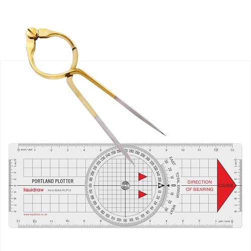
Portland Navigation Triangle Plotting Protractor
The Portland Navigation Triangle Plotting Protractor is engineered for precision chartwork and professional plotting, offering high-contrast graduations and a stable geometry favored by navigators and cartographers. It occupies a middle ground between the all-weather, economical Rite in the Rain piece and the premium, marine-focused Weems & Plath tool — typically priced slightly higher than field protractors but lower than specialist nautical instruments while delivering finer angular accuracy. This makes it a cost-effective choice for users who need drafting-level precision on paper charts without paying for full marine-grade finishes.
Weems & Plath Chart Plot Military Style Protractor
The Weems & Plath Chart Plot Military Style Protractor is the market leader for nautical and professional chart plotting, built from marine-grade materials with exceptionally crisp markings and ergonomic design for sustained use on deck or in the chartroom. Its technical superiority and premium materials command a higher price than the Silva, Rite in the Rain, and Portland Navigation options, but that investment pays off for mariners and professionals who require long-term durability, corrosion resistance, and the most refined plotting performance. Compared with the others on this list, it is the specialist choice where charting precision and material resilience are the overriding priorities.

Why accurate plotting tools matter: research and practical benefits
Scientific and applied studies in navigation, human factors, and field surveying support the benefits of accurate, legible plotting tools. Research shows that appropriate visual reference tools reduce cognitive load, lower bearing and distance errors, and speed decision making when navigating with topographic maps. Studies in outdoor education and orienteering demonstrate that training with dedicated plotting protractors improves map reading skills and reduces common mistakes such as grid convergence errors. In surveying and mapping workflows, precise scales and coordinate rulers reduce post-processing correction and improve data consistency.
Human factors research: clear graduations and contrasting marks reduce misreading and improve speed when plotting bearings and distances.
Orienteering and education studies: learners who use dedicated plotting tools commit fewer navigational errors and gain map orientation skills faster.
Survey and field practice: using accurate map scales and UTM/MGRS rulers decreases measurement drift and improves alignment between field notes and map coordinates.
Material science findings: coated plastics and corrosion-resistant metals extend tool life in wet, freezing, and abrasive Canadian field conditions.
Frequently Asked Questions
Which protractor should I get for grid-to-true work?
Choose the MapTools Super GTA Tool: it’s built to convert Grid, True, and Azimuth bearings directly on map scales for precise grid-to-true angle work, with a 4.1 rating and CAD $28.97 CADprice.
What exact map scale markings does C-Thru W-45 include?
The C-Thru W-45 Protractor has common map scale markings for 1:50k/1:250k use, plus multiple degree markings and ruler edges for quick distance and bearing work, and it averages 4.3 stars.
Is Silva Expedition Type 4 worth paying more than MapTools?
Silva Expedition Type 4 Military Protractor costs CAD $29.05 and is rated 4.8 stars, while MapTools Super GTA Tool is also CAD $28.97 CADwith a 4.1 rating, so Silva gives higher rating value at the same price.
Can Silva Expedition Type 4 align with compass-style plotting?
Yes—the Silva Expedition Type 4 Military Protractor uses transparent, rigid construction with a center alignment hole for compass use, and it has a 360° degree ring with fine graduations, rated 4.8 stars.
Conclusion
In Canada, choosing the right map plotting protractor or scale comes down to matching accuracy, durability, and ease of use to your needs. The top six options for 2026 include MapTools Super GTA Tool, C-Thru W-45 Protractor, Silva Expedition Type 4 Military Protractor, Military UTM/MGRS Coordinate Scale Map Protractor by RITE IN THE RAIN, Portland Navigation Triangle Plotting Protractor, and Weems & Plath Chart Plot Military Style Protractor. For an all-around balance of precision, versatility, and field durability, the MapTools Super GTA Tool stands out as the best choice among these main options. I hope you found what you were looking for; you can refine or expand your search using the site search or filters to narrow by scale type, material, or intended use.